 |
 |
 |
|
 |
 |
 |
 |
 |
 |
 |
In the NewsIs There a Drought in the Sierra?
date posted: December 22 2005
Lake Tahoe Report #95
Dec. 3, 2004
By John Cobourn and Heather Segale
The term “drought” seems incongruous when applied to the Sierra. Yet the Truckee, Carson and Walker Rivers, which receive most of their water from Sierra snowstorms, are in the midst of a multiyear drought. Ranchers and urban residents downstream are hoping this winter’s storms will end this drought. Many are encouraged by the stormy start to the winter, which prompted record-breaking early opening dates at some ski resorts. The news of a mild El Nino event currently in progress also has people excited about the possibility of a wet winter. Yet, a recent forecast from National Oceanic and Atmospheric Administration Climate Prediction Center only predicts wetter than normal conditions south of the Tahoe Basin for sometime between January and May.
Drought is defined differently in different areas. Some scientists define a drought year as any year when the average precipitation for a watershed is less than 70 percent of the average annual precipitation. However, water levels in our engineered reservoirs also play a role in defining whether we are in a multiyear drought. This is because downstream users rely on two types of reservoirs, the frozen snowpack and the water held in dams and lakes.
The Tahoe Basin has experienced below-average precipitation each of the last five years. Only one of those years, 2001, was below 70 percent of average, with 57 percent of average precipitation. However, the lake level this fall was below its natural rim, and more than 6 feet below the top of the storage dam in Tahoe City. Other local reservoirs are also low, so the Truckee River Basin is considered to be in a drought status. In fact, many western states – Arizona, New Mexico, Nevada, Utah, Idaho and Montana – are in the midst of a multiyear drought.
It is ironic then, that this October was actually extremely wet locally and in much of California. The Central Sierra Snow Laboratory in Soda Springs at Donner Summit recorded 48 inches of snow in October, surpassing the previous record of 36 inches set in 2000. Record rains also occurred in many parts of southern California in October. Sacramento, with records dating back to the mid-1800s, reported its fifth wettest October ever.
With these impressive statistics and the heavy snows over the Thanksgiving weekend, it is easy to see how some may think we are on the way to an above average snow year. When Gary Barbato, of the National Weather Service in Reno, looked at the top 10 wettest Octobers at Tahoe City, he found that in five of the 10, the winters went on to receive above-average precipitation. Of the others, two were average, two were below average (60 percent to 89 percent), and one was much below average (below 60 percent). Up at the Snow Lab in Soda Springs, the previous snowiest October, in 2000, led to a disappointing 61 percent of average accumulation for that winter.
So, while we can hope, we cannot safely predict that this winter will put an end to the current drought. Even with ongoing research on weather patterns such as El Nino, La Nina and other regional trends, scientists can only wait and see.
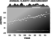
One interesting result of multiyear droughts in the past has been a temporary improvement in Lake Tahoe’s water quality. In the famous seven-year drought from 1987 to 1993, Tahoe had six years in a row with below-average snowpack. If one were to look at the UC Davis Secchi Depth data for only the years 1983 to 1992, it would appear that the water clarity trend in the lake was improving. In fact, the long-term declining trend in water transparency resumed when the normal pattern of stormy winters returned. It could turn out again that our current drought will yield a similarly deceptive short-term improvement in clarity, starting in 1997.
The interconnections of ocean currents, sea temperatures, regional long-term weather patterns and their impacts on water quality in Lake Tahoe are complicated indeed. When one factors in research and predictions about global warming, the picture becomes even more complex. Next week we will examine some predictions about climate change.
More News: Pathway 2007 Tackles Soil Health, Air and Water Quality, Lake Tahoe Report #145 Nov. 29, 2005 By John Cobourn and . . . read this news. Tahoe’s Fish, Wildlife and Wetlands Being Considered in Pathway Planning, Lake Tahoe Report #144 Nov. 22, 2005 By John Cobourn and Heather . . . read this news. Pathway 2007: Creating a Shared Vision for Lake Tahoe, Lake Tahoe Report #143 Nov. 14, 2005 By John Cobourn and Heather . . . read this news. Vision of Tahoe’s Future Changes Over the Decades, Lake Tahoe Report #141 Nov. 1, 2005 By John Cobourn and Heather . . . read this news. New Zealand Mudsnails Threaten Tahoe and Truckee River Waters, Lake Tahoe Report #140 Oct. 24, 2005 By John Cobourn and Heather . . . read this news. New Subdivision Will Be Monitored for Water Quality Impacts, Lake Tahoe Report #139 Oct. 17, 2005 By John Cobourn and Heather . . . read this news. Biodiesel Film Festival Comes to Tahoe, Lake Tahoe Report #138 Oct. 10, 2005 By John Cobourn and Heather . . . read this news. Green Building Takes Root at Lake Tahoe and Truckee, Lake Tahoe Report #137 Oct. 3, 2005 By John Cobourn and Heather . . . read this news. League Determined to Keep Tahoe Blue, Lake Tahoe Report #136 Sep. 26, 2005 By John Cobourn and Heather . . . read this news. Martis Wildlife Area Trails Need Restoration, Lake Tahoe Report #134 Sep. 12, 2005 By John Cobourn and Heather . . . read this news. Tenth Annual Truckee River Day is October 16, Lake Tahoe Report #135 Sep. 19, 2005 By John Cobourn and Heather . . . read this news. Tahoe Eyes Solar Sailor Ferryboat, Lake Tahoe Report #133 Sep. 6, 2005 By John Cobourn and Heather . . . read this news. NASA Satellites Rely on Tahoe Buoys for Validation, Lake Tahoe Report #132 Aug. 29, 2005 By John Cobourn and Heather . . . read this news. Old Fish Hatchery Renovation Planned, Lake Tahoe Report #131 Aug. 22, 2005 By Heather Segale and John . . . read this news. New Science Center Cornerstone Ceremony Aug. 20, Lake Tahoe Report #130 Aug. 8, 2005 By Heather Segale and John . . . read this news. New UNR Website Catalogs Decades of Tahoe Research, Lake Tahoe Report #129 Aug. 8, 2005 By John Cobourn and Heather . . . read this news. It Happens, Lake Tahoe Report #128 Aug. 8, 2005 By Heather Segale and John . . . read this news. Scientists Study Submarine Geology of Lake Tahoe, Lake Tahoe Report #127 Aug. 1, 2005 By John Cobourn and Heather . . . read this news. UNR Scientists Study Earthquake Faults at Tahoe, Lake Tahoe Report #126 July. 15, 2005 By Heather Segale and John . . . read this news. Events Focus on Living with Fire and BMPs at Tahoe, Lake Tahoe Report #125 July. 11, 2005 By Heather Segale and John . . . read this news. Removing the Invasive Aquatic Weed: Eurasian Watermilfoil, Lake Tahoe Report #124 July. 5, 2005 By Heather Segale and John . . . read this news. Why Measure Water Clarity in Lake Tahoe?, Lake Tahoe Report #3 Feb. 19, 2003 By John Cobourn, Water Resource . . . read this news. What You Can Do To Protect Water Quality, Lake Tahoe Report #2C Hike only on existing trails. Use fertilizers and . . . read this news. KOLO-TV and LTEEC Feature Weekly Information on Lake Tahoe Environment, Lake Tahoe Report #1 Feb. 5, 2003 By John Cobourn and Heather . . . read this news. What do Watersheds Matter?, Lake Tahoe Report #2 Feb. 12, 2003 By Heather Segale and John . . . read this news. Tahoe Communities Use Various Recycling Strategies, Lake Tahoe Report #26 July 30, 2003 By John Cobourn and Heather . . . read this news. Where Does Your Drinking Water Come From?, Lake Tahoe Report #27 Aug. 6, 2003 By John Cobourn, Water Resource . . . read this news. The Forest Service Accomplishes Much with Help from the Lake Tahoe Restoration Act, Lake Tahoe Report #28 Aug. 13, 2003 By John Cobourn, Water Resource . . . read this news. Managing Vegetation for Wildfire Prevention, Lake Tahoe Report #29 Aug. 20, 2003 By John Cobourn, Water Resource . . . read this news. Good News for Tahoe from Federal and State Governments, Lake Tahoe Report #30 Aug. 27, 2003 By John Cobourn, Water Resource . . . read this news. Invasive Weeds Threaten Lake Tahoe, Lake Tahoe Report #31 Sep. 3, 2003 By John Cobourn and Heather . . . read this news. Spotlight on the California Tahoe Conservancy, Lake Tahoe Report #32 Sep. 10, 2003 By John Cobourn, Water Resource . . . read this news. Forest Stewardship: Learn by Doing, Lake Tahoe Report #33 Sep. 17, 2003 By John Cobourn, Water Resource . . . read this news. Stream and Wetlands Restoration, Lake Tahoe Report #24 Sep. 24, 2003 By John Cobourn, Water Resource . . . read this news. Using the Sense of Place as a Catalyst for Learning, Lake Tahoe Report #35 Oct. 1, 2003 By John Cobourn, Water Resource . . . read this news. Tahoe Gets Public Transit Upgrade, Lake Tahoe Report #36 Oct. 8, 2003 By John Cobourn, Water Resource . . . read this news. Research Continues to Help Preserve Lake Tahoe, Lake Tahoe Report #37 Oct. 15, 2003 By John Cobourn, Water Resource . . . read this news. Prescribed Fire: Managing Smoke and Fire in the Tahoe Basin, Lake Tahoe Report #38 Oct. 22, 2003 By John Cobourn, Water Resource . . . read this news. Blackwood Creek Restoration - A Big Step towards a Better Tahoe, Lake Tahoe Report #40 Nov. 5, 2003 By Rex Norman, USDA Forest . . . read this news. Conserving Tahoe’s Most Imperiled Plant: Tahoe Yellow Cress, Lake Tahoe Report #41 Nov. 12, 2003 By John Cobourn, Water Resource . . . read this news. Improper Snow Removal Can Be Damaging to Lake Tahoe, Lake Tahoe Report #42 Nov. 19, 2003 By John Cobourn, Water Resource . . . read this news. Tahoe’s Bears Prepare to Hibernate, Lake Tahoe Report #44 Dec. 3, 2003 By John Cobourn and Heather . . . read this news. Drinking Water – Another Reason to Protect Lake Tahoe, Lake Tahoe Report #45 Dec. 10, 2003 By John Cobourn and Heather . . . read this news. Ski Area Erosion, Lake Tahoe Report #46 Dec. 17, 2003 By John Cobourn, Water Resource . . . read this news. State Road Departments Help Protect Water Quality While Keeping Roads Safe, Lake Tahoe Report #49 Jan. 7, 2004 By John Cobourn, Water Resource . . . read this news. Tahoe Goes High-Tech With TIIMS, Lake Tahoe Report #50 Jan. 14, 2004 By John Cobourn, Water Resource . . . read this news. Snowmobiling Controversial at Tahoe, Lake Tahoe Report #51 Jan. 21, 2004 By John Cobourn, Water Resource . . . read this news. Wildlife Copes with Winter, Lake Tahoe Report #52 Jan. 28, 2004 By Heather Segale, Environmental Education . . . read this news. Biologists Study Sensitive Wildlife in the Tahoe Basin, Lake Tahoe Report #53 Feb. 4, 2004 By John Cobourn, Water Resource . . . read this news. Cross-country Skiing Can be Easy on the Environment and on You, Lake Tahoe Report #54 Feb. 11, 2004 By John Cobourn, Water Resource . . . read this news. One Year Anniversary of the Lake Tahoe Report, Lake Tahoe Report #55 Feb. 18, 2004 By John Cobourn, Water Resource . . . read this news. Outdoor Classrooms Can Help Kids Do Better on School Tests, Lake Tahoe Report #56 Feb. 25, 2004 By John Cobourn, Water Resource . . . read this news. Air Quality Affects Our Health the Lake’s Health, Lake Tahoe Report #57 March 3, 2004 By John Cobourn, Water Resource . . . read this news. Transportation Planners Seek to Reduce Traffic, Protect Environment, Lake Tahoe Report #58 March 10, 2004 By John Cobourn, Water Resource . . . read this news. Fire Safe Councils Invite Citizens to Participate, Lake Tahoe Report #59 March 17, 2004 By John Cobourn, Water Resource . . . read this news. Tahoe Conservation Agencies Offer Workshop to Building Industry, Lake Tahoe Report #60 March 24, 2004 By John Cobourn, Water Resource . . . read this news. New TRPA Director has a Vision for Change, Lake Tahoe Report #61 March 31, 2004 By John Cobourn, Water Resource . . . read this news. How Do Tahoe Residents Feel About Efforts to Save Lake Tahoe?, Lake Tahoe Report #62 April 7, 2004 By John Cobourn, Water Resource . . . read this news. Pathway 2007: A Planning Effort to Protect Lake Tahoe, Lake Tahoe Report #63 April 21, 2004 By John Cobourn, Water Resource . . . read this news. Tahoe’s Dogs Make an Impact on Lake Water Quality, Lake Tahoe Report #64 April 28, 2004 By John Cobourn, Water Resource . . . read this news. Tahoe’s Construction Season Runs May 1 – Oct. 15, Lake Tahoe Report #65 May 5, 2004 By John Cobourn, Water Resource . . . read this news. Scientific Research Conference to Address Tahoe Environment, Lake Tahoe Report #66 May 12, 2004 By John Cobourn, Water . . . read this news. Citizens Get Opportunity to Test Water Quality May 22, Lake Tahoe Report #67 May 19, 2004 By John Cobourn, Water Resource . . . read this news. Public Invited to Help Create Community Fire Plans, Lake Tahoe Report #68 May 26, 2004 By John Cobourn, Water Resource . . . read this news. Public Agencies Could Acquire Incline Lake Property, Lake Tahoe Report #107 March 4, 2005 By John Cobourn and Heather . . . read this news. TRPA has New Strategy to reduce Building Permit Review Time, Lake Tahoe Report #108 March 11, 2005 By John Cobourn and Heather . . . read this news. Scientists Study Reintroduction of Lahontan Cutthroat Trout in the Tahoe Basin, Lake Tahoe Report #71 June 14, 2004 By John Cobourn and Heather . . . read this news. Take a Glimpse of Tahoe’s Natural History, Lake Tahoe Report #10 April 9, 2003 By John Cobourn and Heather . . . read this news. Good Snow Removal Practices Can Help Prevent Pollution of Lake Tahoe, Lake Tahoe Report #5 March 5, 2003 By John Cobourn and Heather . . . read this news. Take Steps to Control Air Pollution at Lake Tahoe, Lake Tahoe Report #6 March 12, 2003 By John Cobourn and Heather . . . read this news. Where Does Tahoe’s Water Pollution Come From?, Lake Tahoe Report #8 March 26, 2003 By John Cobourn and Heather . . . read this news. Kids Learn to Prevent Water Pollution at Tahoe, Lake Tahoe Report #9 April 2, 2003 By John Cobourn and Heather . . . read this news. Local Schoolchildren Ready for Earth Day, Lake Tahoe Report #11 April 16, 2003 By John Cobourn and Heather . . . read this news. Lake Protection Efforts Seen as Model of Collaboration, Lake Tahoe Report #12 April 23, 2003 By John Cobourn and Heather . . . read this news. Citizens Get Opportunity to Test Water Quality, Lake Tahoe Report #13 April 30, 2003 By John Cobourn and Heather . . . read this news. From Under the Water – Part One, Lake Tahoe Report #14 May 7, 2003 By John Cobourn and Heather . . . read this news. From Under the Water – Part Two, Lake Tahoe Report #15 May 14, 2003 By John Cobourn and Heather . . . read this news. Wet Weather Construction can be Especially Hard on the Lake, Lake Tahoe Report #16 May 21, 2003 By John Cobourn and Heather . . . read this news. Do We Have Old-growth Forests at Tahoe?, Lake Tahoe Report #17 May 28, 2003 By John Cobourn and Heather . . . read this news. Prevent Runoff from Polluting Lake Tahoe, Lake Tahoe Report #18 June 4, 2003 By John Cobourn and Heather . . . read this news. Enjoy the Backcountry – and Take Care of It!, Lake Tahoe Report #19 June 11, 2003 By John Cobourn and Heather . . . read this news. Neighborhood Sets Best Management Practices Goals, Lake Tahoe Report #47 December 19, 2003 By John Cobourn and Heather . . . read this news. Lakes Tahoe and Baikal Inspire Unique Russian-American Partnership, Lake Tahoe Report #20 June 18, 2003 By John Cobourn and Heather . . . read this news. Counties, States and Feds Work Together to Solve Lake’s Problems, Lake Tahoe Report #7 March 14, 2003 By John Cobourn and Heather . . . read this news. Use Lawn Fertilizers Sparingly at Lake Tahoe, Lake Tahoe Report #21 June 25, 2003 By John Cobourn and Heather . . . read this news. To Protect Water Quality, Allow your Landscape to Act Like a Sponge, Lake Tahoe Report #22 July 2, 2003 By John Cobourn and Heather . . . read this news. What Kinds of Best Management Practices Work Best?, Lake Tahoe Report #23 July 9, 2003 By John Cobourn and Heather . . . read this news. Choose Plants for Your Landscape Wisely, Lake Tahoe Report #24 July 16, 2003 By John Cobourn and Heather . . . read this news. Avoid Summer Water Waste, Lake Tahoe Report #25 July 23, 2003 By John Cobourn and Heather . . . read this news. Can Lake Tahoe Be Saved?, Lake Tahoe Report #4 February 24, 2003 By John Cobourn and Heather . . . read this news. Eagle Falls Work Will Enhance Water Quality, Lake Tahoe Report #43 November 21, 2003 By Rex Norman, USDA Forest . . . read this news. Local Association Advocates for Affordable Housing, Lake Tahoe Report #148 December 19, 2005 By John Cobourn and Heather . . . read this news. Monitor Scientific Weather Stations on the Web, Lake Tahoe Report #147 December 12, 2005 By John Cobourn and Heather . . . read this news. New Water Quality Planning Tool for Tahoe: The TMDL, Lake Tahoe Report #48 April 19, 2004 By John Cobourn and Heather . . . read this news. Homeowners Play an Important Role in Saving, Lake Tahoe Report #69 May 28, 2004 By John Cobourn and Heather . . . read this news. UC Davis and Sierra Nevada College Will Build, Lake Tahoe Report #70 June 7, 2004 By John Cobourn and Heather . . . read this news. New Approach for Managing Fallen Pine Needles, Lake Tahoe Report #71 June 14, 2004 By John Cobourn and Heather . . . read this news. Scientists Assess Fire Risk in all Tahoe Communities, Lake Tahoe Report #73 June 25, 2004 By John Cobourn and Heather . . . read this news. Volunteers Monitor Stream Water Quality, Lake Tahoe Report #74 July 6, 2004 By John Cobourn and Heather . . . read this news. Tahoe Students Care for Their Schoolyards…, Lake Tahoe Report #75 July 9, 2004 By John Cobourn and Heather . . . read this news. Green Boating at Lake Tahoe, Lake Tahoe Report #76 July 20, 2004 By John Cobourn and Heather . . . read this news. Tahoe’s Boaters Must Be Safe and Know the Rules, Lake Tahoe Report #77 July 26, 2004 By John Cobourn and Heather . . . read this news. Boaters Can Help Prevent the Spread of Eurasian Watermilfoil, Lake Tahoe Report #78 Aug. 2, 2004 By Susan Donaldson,Water Quality Education . . . read this news. Dalmatian Toadflax Tales of Woe, Lake Tahoe Report #79 Aug. 10, 2004 By Susan Donaldson, Water Quality . . . read this news. Protect your Property from Wildfire While Protecting Lake Tahoe, Lake Tahoe Report #80 Aug. 17, 2004 By John Cobourn and Heather . . . read this news. West Nile Virus Reaches the Lake Tahoe Basin, Lake Tahoe Report #81 Aug. 23, 2004 By John Cobourn and Heather . . . read this news. Fertilizer Use Near the Shore Can Speed Algae Growth, Lake Tahoe Report #82 Aug. 27, 2004 By John Cobourn and Heather . . . read this news. USDA Forest Service Upgrades Some Roads, Decommissions Others, Lake Tahoe Report #83 Sept. 7, 2004 By John Cobourn, Heather Segale,and . . . read this news. Why is Lake Tahoe Blue?, Lake Tahoe Report #84 Sept 13, 2004 By John Cobourn and Heather . . . read this news. Lake Tahoe Fire Plans Nearing Completion, Lake Tahoe Report #85 Sept 17, 2004 By John Cobourn and Heather . . . read this news. Kokanee Salmon Differ from Other Lake Tahoe Trout, Lake Tahoe Report #86 Sept. 27, 2004 By John Cobourn and Heather . . . read this news. Export of Tahoe’s Treated Sewage Protects the Lake, Lake Tahoe Report #87 Oct. 4, 2004 By John Cobourn and Heather . . . read this news. Schoolchildren Learn About the Environment Firsthand, Lake Tahoe Report #88 Oct. 8, 2004 By John Cobourn and Heather . . . read this news. Visit Lake Tahoe’s Demonstration Gardens, Lake Tahoe Report #89 Oct. 15, 2004 By John Cobourn and Heather . . . read this news. Teachers and Students Complete Schoolyard Restoration Project, Lake Tahoe Report #90 Oct. 26, 2004 By John Cobourn and Heather . . . read this news. Forest Thinning Projects Require Careful Elimination of Fuels, Lake Tahoe Report #91 Nov. 8, 2004 By John Cobourn and Heather . . . read this news. Storm Runoff is More Damaging in Disturbed Watersheds, Lake Tahoe Report #92 Nov. 15, 2004 By John Cobourn and Heather . . . read this news. How Does Shoreline Erosion Rank with Other Sources of Lake Pollution?, Lake Tahoe Report #93 Nov. 23, 2004 By John Cobourn and Heather . . . read this news. Forecasters Predict Mild El Niño Weather Pattern, Lake Tahoe Report #94 Nov. 30, 2004 By John Cobourn and Heather . . . read this news. Is There a Drought in the Sierra?, Lake Tahoe Report #95 Dec. 3, 2004 By John Cobourn and Heather . . . read this news. How Will Climate Change Affect the Sierra?, Lake Tahoe Report #96 Dec. 10, 2004 By John Cobourn and Heather . . . read this news. Drinking Water From Lake Tahoe is Treated, Lake Tahoe Report #97 Dec. 20, 2004 By John Cobourn and Heather . . . read this news. Commercial Car Washes Conserve Water, Lake Tahoe Report #98 Dec. 27, 2004 By John Cobourn and Heather . . . read this news. Your Chance Is Here to Help Plan Tahoe’s Future, Lake Tahoe Report #99 Jan. 3, 2005 By John Cobourn and Heather . . . read this news. Foresters, Forest Historians Debate Over Tahoe Forest Thinning, Lake Tahoe Report #100 Jan. 14, 2005 By John Cobourn and Heather . . . read this news. UNR Launches Academy for the Environment, Lake Tahoe Report #101 Jan. 24, 2005 By John Cobourn and Heather . . . read this news. Is Biodiversity an Issue at Lake Tahoe?, Lake Tahoe Report #102 Jan. 31, 2005 By John Cobourn and Heather . . . read this news. Northstar Developer Invests in Hybrid SUV Technology, Lake Tahoe Report #103 Feb. 7, 2005 By John Cobourn and Heather . . . read this news. Pathway 2007 Gathers Public Input on Vegetation and Scenic Visions for Tahoe, Lake Tahoe Report #142 Nov. 8, 2005 By John Cobourn and Heather . . . read this news. New Research Points to Real Causes of Clarity Loss in Lake Tahoe, Lake Tahoe Report #109 March 18, 2005 By John Cobourn and Heather . . . read this news. Public Opinion Research Helps Chart 20-Year Vision for Tahoe, Lake Tahoe Report #110 March 28, 2005 By John Cobourn and Heather . . . read this news. Lake Tahoe’s Future Depends on You – Top 10 Ways to Save Lake Tahoe, Lake Tahoe Report #111 April 4, 2005 By John Cobourn and Heather . . . read this news. Tahoe’s Unique Features Depend on a Fragile Watershed, Lake Tahoe Report #112 April 11, 2005 By John Cobourn and Heather . . . read this news. Earth Day Celebrates 35-year History, Lake Tahoe Report #113 April 15, 2005 By John Cobourn and Heather . . . read this news. 2005 Earth Day Celebrations to Continue Zero Waste Recycling, Lake Tahoe Report #114 April 25, 2005 By John Cobourn and Heather . . . read this news. Local Businesses Can be Recognized as “Lake-Friendly”, Lake Tahoe Report #115 May 2, 2005 By John Cobourn and Heather . . . read this news. Moonshine Ink is Truckee’s Bilingual Newspaper, Lake Tahoe Report #116 May 9, 2005 By John Cobourn and Heather . . . read this news. Best Management Practices Workshop Trains Contractors, Lake Tahoe Report #118 May 23, 2005 By John Cobourn and Heather . . . read this news. Wildlife Shelter Cares for Injured or Orphaned Animals, Lake Tahoe Report #119 May 30, 2005 By John Cobourn and Heather . . . read this news. Schoolyard Habitat Program Comes to Kings Beach, Lake Tahoe Report #149 Dec. 23, 2005 By John Cobourn and Heather . . . read this news. Can We Save Our Sugar Pines?, Lake Tahoe Report #123 June 28, 2005 By John Cobourn and Heather . . . read this news. Scientists See Progress in Reintroduction of, Lake Tahoe Report #122 June 21, 2005 By John Cobourn and Heather . . . read this news. Recycling Programs Vary at Lake Tahoe, Lake Tahoe Report #121 June 13, 2005 By John Cobourn and Heather . . . read this news. Thirty-Five Years of Service, Lake Tahoe Report #120 June 6, 2005 By John Cobourn and Heather . . . read this news. Citizens Get Chance to Test Water Quality, Lake Tahoe Report #117 May 16, 2005 By John Cobourn and Heather . . . read this news. Fifth-graders Learn About the Environment While Snowshoeing at 9,000 Feet, Lake Tahoe Report #105 Feb 22, 2005 By John Cobourn and Heather . . . read this news. USDA Forest Service Offers “Ski With a Ranger” Program, Lake Tahoe Report #106 Feb. 24, 2005 By John Cobourn and Heather . . . read this news. Can We Preserve our View of the Starry Night?, Lake Tahoe Report #104 Feb. 10, 2005 By John Cobourn and Heather . . . read this news. Special Report: Lake Tahoe Air Quality, Meteorology and Air Quality in the Lake Tahoe Airshed There are . . . read this news. Meet Greg Crofton, Tribune Environmental Reporter, In February of 2002 Greg Crofton became the environmental reporter . . . read this news. “The National Map” Lake Tahoe Area Pilot Project Underway, The U.S. Geological Survey (USGS) is developing “The National Map” . . . read this news. Fifteen Things You Can Do To Make a Difference in Your Watershed, Learn about your watershed. Use EPA's Nonpoint Source Program web pages . . . read this news. Bats Are Part of Lake Tahoe’s Ecosystem, Lake Tahoe Report #152 January 17, 2006 By John Cobourn and Heather . . . read this news. Yuck - Algae in Lake Tahoe, There are two major types of algae found in Lake . . . read this news. Living With Bears, By Ann Bryant, Executive Director, BEAR League Bears are probably the . . . read this news. Tahoe Clarity Hits 10-Year High, In 2002, Lake Tahoe was the clearest it had been . . . read this news. Tahoe Interagency Information Management System (TIIMS) Under Development, The Tahoe Interagency Information Management System (TIIMS) project will provide . . . read this news. |